Another classic lane up steep rocky hills then flat bleak moorland, either way is possible ,but since there is a few ROW's off this lane I will deal with the main popular route. Starting from the north at SJ170370, look out for phone box on the UCR. The lane starts off almost straight away into a steep rocky climb with a stream of water flowing down, the first 300 yards are about the worse before it levels out. On top keep to the main track, at SJ159355 the track digs into the ground so quite steep inclines. Look out for the other ROW's going east, but unless you have the "knowledge" don't temp them as many laners have come to grief in the steep V valley. The south end is at SJ157336.
Theres many names to this lane its very popular with a lot of groups, partly access between the two valleys, common name White Stones cause of the large Stones painted white on the top, however paint fades and its not always been there others include Welsh names. Its also called "Up the Hill" since many do this from the south, its the nearest lane to Llanarmon D.C. which has 2 Pubs. Warfarers arms has a public bar with stone floor plus outside loos, more suitable for those with muddy feet. It has a children playground in the back and outside seats. There is also some Toilets in the community centre, which has spaces for several vehicles off the main road, safer for the children etc.
www.multimap.com/map/browse.cgi?lat=52.9148&lon=-3.2506&scale=25000&icon=x
Wednesday, December 06, 2006
Top of the V-gully
There's a lane at the top of the V-gully in grid SJ1838, not a bad little lane muddy and plenty of branches. Going west to east is popular since it carries on to the V-gully. If you are leading a group and someone complans about this, then nows' the time to dump them at the cross roads before the "V". If going east to west then watch out, I have known at least 2 laners too lose diffs and tie-rods on just this short section. Great for novices been so short but safe, expect at least scraches if not more.
The Drovers
Its not a green lane as such but a "Blacklane" since its nealy all tarmac, but in very poor state of repair. Still popular with laners as a access road from A5 to the majority of the lanes in the area. Starting at the north end SJ152426 on the A5 in Glyndyfrdwy, look for a small church. The Climb is very steep and long with great views of the valley below, be carefull in winter as ice forms on the road following water running off the hillside, and its a hell of a drop. At the top the tracks alongside are favourites with "Mud Pluggers" although recently fenced off to prevent them. Look out for the now dis-used car park at SJ161383, it was a great place to "play in". This was once popular with trampers since it provided a flat route west to the Waterfalls at SJ131369. Once you could drive all the way there and onto Cynwyd, but the route was downgraded years ago. The junction at SJ168380 leads to the Top of the V-Gully and the "V" itself (see sister blog; click on profile) while the "Blacklane" continues to Tyn-y-celyn at SJ177371. Either way is possible and non damaging.
Thursday, October 26, 2006
Cefn Gwyn
Pleasant lane can be done in a 4x2, nice views steep incline at north end, great in snow hence why I've included it. North point @ SJ 128 302 : south point @ SJ 133 274.
There's another lane close by in grid SJ 15 27 , nice lane with a bit of a water crossing.
Both these are non damaging.
There's another lane close by in grid SJ 15 27 , nice lane with a bit of a water crossing.
Both these are non damaging.
Cefn Hir-fynydd (Spashly Lane)
 Series Breakdown - common on this lane
Popular lane part of the wayfarers route, along the top of open countryside with excellent views, part moor, part uphill farmland. Plenty of water and in winter the mud, hence the name, great for "Mud Plugging" without the need for "Mud tyres" although you can get grounded out with smaller tyres in some of the ruts. Flat along the top it's west point start is @ SJ 147 31o: North @ SJ 173 323 which crosses a UCR and forms another lane (start point @ SJ 177 335 along side farm building). East route @ SJ 178 327 (difficult tight turn so not used much). Either way is suitable, not a damaging lane, but allow time for breakdowns as petrol engines suffer on this lane, and for photo shoots. Indians can be hostile, that is the trampers as popular with them, farmer ok with 4x4 as long as you keep to the track, but he does'nt like the bikes who tend not too.
As of dec 2006 I've been told the east end about 300 is now a Restricted Byeway (exRUPP) but groups are still using it, so a warning here the end might not be a ROW, of course you could start other end and turn round, well worth it.
Conquering Hero

Disco on the hero
Another one of those steep over top "pass" lanes we come to expect in Wales, long steep climb hugging the side of a Mountain. South point starts @SJ 178 455 at the end of a UCR leading from Rhewel SJ183 449, (on the edge of two maps, here you might need OS116). North point @SJ155 472 (its a gate which leads into a "fenced lane" off a UCR off A5104). Great views and a brilliant drop, some mud on the top but do'nt leave the lane as the "Hobby Bobbies" are active here proscuting illegal off roaders doing the "Three peaks" from the Horseshoe Pass. Note the sarces on the hillside can be seen from miles away. Watch out for the "White boulders" @ SJ163 468, the farmers placed them to make sure you stick to the RoW, as the lane goes through the gate at right angles. A great lane to start or finsh with, as it brings you out on the A5104 closer to Deeside. Suitable either way and none damaging except light scratches.
Wednesday, October 25, 2006
Read Me
 About to start- lane leads to the steps
The idea of this blog is to advise greenlaners, novices or visitors to this area lanes they can drive in the Corwen area in standard 4x4's. All have been driven in 2006, you will need a maps of the area; OS Landranger Bala 125 a must; & maybe Denbigh 116. If possible plan the route before you set off, but not necssary stick to it, Grid refs given in nearly all posts.
Strongly advise you go in a group, (email me above, I am often in the area) in fact do not advise anyone to go alone unless you have a good rescue plan. I've known people to be stuck for days. Corwen car park @ SJ 078 435 is a good place to meet up (well stocked mini-super market), and fill up with fuel before you get there. Corwen area suffers as most country areas do from no garages.
Take the following
Plenty of water, extra food, hot drinks or means of, extra warm clothes, waterproof coat.
Mobile phone (will not work in places) and change for payphones
Strong ropes or straps, shakles, spade, jack, spare tyre, and wheel lock tools
Some basic tools, WD40, rags, torch etc.
Remember take your time, allow for breakdowns, stops, and photo shoots.
Have a great time, enjoy it and have fun, get muddy, cold, wet, tired, but be safe. Cannot expect any responsablity for anything that might happen. Due to the nature of these lanes damage might occur that can be of a serious nature.
The Steps (Pheasent Steps or Chicken leg run)


Uphill on the steps - past the tricky bit
WARNING READ THIS AND TAKE NOTE
A lane you must treat with respect, long steep rocky lane on the side of a hill with a nice drop below. Worst part is near the bottom with a large rock to get round, but just before it is a step that faces out (towards the drop), novices can do it, but will need expert guidance from persons who know the lane. Best get out and view the ground, also a good photo shot here, I've know experienced laners to end up in the pheasant pens before now, hence the name. Neither is the farmer happy here so expect no help. Downhill (north to south) is easier, but up hill can be achieved, you can expect the lanes at the top to be difficult, with deep mud filled ruts.
Warning in winter ice easily forms on the rocks due to the water running off the hillside and the aspect. Recce it first, at the top there is a place to turn round. If done before do not be over confiancent. Still a great lane despite the warning, just be careful! Pleasant place to stop at the bottom, lane takes about 1/2 hour. Serious damage if you roll both to yourself and your truck, otherwise expect minor body damage underside and rear quarters.
Added Dec 2006
Footnote : There has been some damage to the bank around the "rock" at the bottom, laners who have been doing this section for years are coming to grief on this bit. We don't think any worse than before, its the water which is making the the stones in the bank loose. This happens most wet winters, as the run off is turning it into a slag heap. Whats needed is careful guidance from people who know what they are doing, those who do trials (RTV's) seem to have less problems.
There also seems to be more laners prepared to do this lane in winter, and without an experienced person on hand who knows the lane, we have come across groups with no idea as what to expect, so have listed it's location as a warning. If you never done this lane before I would advise you to view it from the south, stop at the sheep pens (two gates close to each other) just over the stream and walk up its about 100 yards up. There are some nice lanes you can use to get there if coming form the north. Then go back round if you want to do it.
I've counted 3 recoveries I have done or come across in 2006, and I don't tend to travel it much.
Grid ref. South@ SJ 178 299; north @SJ177 335 the steps are @ SJ 174 304
Don't go though the farm on south end, farmer often blocks the lane, use lane to the west
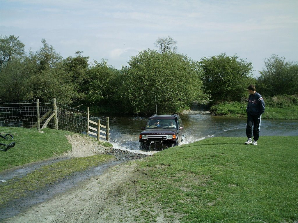
Afon Alwen Ford (Corwen Car Wash)
 Last one though- "Carwash" south side
A classic river crossing, depth of the water varies a lot, if the water is up to the base of the gate on the north side, its deep! A great photo shoot, so could take a group a while to cross. Often the first or last lane on the way home since very close to the A5 (minor road at the lights). The crossing itself is @ SJ 058 428. Apart from a flooded or blown up engine, expect no damage except wet carpets, seats, feet etc. Its all part of the fun.
Lanes 1,2,& 3
There's a few other lanes in grid refs SJ 06 43 which is handy as avoids the A5 lights, and leads to other lanes @ SJ 062 448 - SJ 074 460 (OS116 map) nice pleasent lanes with some water on in winter. None damaging except scratches. Called 1,2, & 3 cause often the first lanes you go on if you meet at the corwen carpark, popular meeting start/stop place.
There's a few other lanes in grid refs SJ 06 43 which is handy as avoids the A5 lights, and leads to other lanes @ SJ 062 448 - SJ 074 460 (OS116 map) nice pleasent lanes with some water on in winter. None damaging except scratches. Called 1,2, & 3 cause often the first lanes you go on if you meet at the corwen carpark, popular meeting start/stop place.
As of Dec 2007 they're has been some concern about damage to fish stocks, but this has been rasied before, its not illegal but just use the ford as a ford and not drive around in the river. Some groups have a temporary ban on its use.
Afon Alwen Ford is often the Welsh used name, the "Car wash" common well known lane, but use of this has caused concern that the Envoniment Agency think we actual wash our trucks in it !, this is illegal in any water course. Other names include the A5 Ford or the A5 Traffic Light Ford.
Blackberry Lane
Pleasant lane which in early Autumn is full of Blackberries, hence the name. East point starts from UCR @ SJ 168 297; north point at farm Pant-y-maen @ SJ 158 305 this is the best route. There's another shorter route from the west @ SJ 155 296. Most groups take the north route since it forms part of the figure of eight route taking in splash lane and the pheasant steps. At certain times of the year you can expect scratches to paint work, otherwise the north route is easy and suitable for novices. Take a bag for the fruit its lovely.
The Wayfarer


This classic long moorland over the top lane is must for those Greenlaners, it also provides a good route from the North to Llanarmon D.C. but either way is suitable. Two main routes from the west which join just before the summit (1700 feet), the northerly route provides a good escape route, but there's an extra lane at Rhos-y-maerdy heading due north comes out @ SJ 058 398. The recommended westerly route starts at copse @ SJ 051 375, there's a lane going west to Llandrillo from this point, but not recommended. If traveling on the B4401 look for the red phone box on the east side, the UCR starts from there. East route starts from UCR @ SJ 128 356. Don't forget to sign the book at the top, and please no "Mud plugging" here. Tends always to be windy and cold at the summit worse if its raining, nice sheltered picnic spot at the bridge @ SJ 072 368 room for a few trucks.
Very pleasant lane, rocky but not one that normally causes damage, except watch out for "Diff lost stone" around SJ 076 366. Takes about an hour, often used as a short cut north from Llanarmon.
Pandy Lane (The Dog Leg)
 Await the next truck- photo shoot difficult due to light.
Lovely forest lane with a steep track to start with, there is just one spot which causes problems. Its been done in standard Series and a 110 with road tyres and no winch, however best go with a group and if needed a winch first. Longer wheelbases cope better, so do Discos. Then a pleasant drive though agricultural country finished off with a very tricky lane at the end, its narrow and expect damage. (please don't use the farmers track its not a RoW unless in emergency).
Best route : south to north. Start points: south SJ 190 361 : north SJ 184 370
Nav. problems south to north: Lane goes right after the stream; just before farm take narrow lane up to UCR (200 yards)
Damage: possible slight damage to bodywork, roof racks, mirrors etc.
Best route : south to north. Start points: south SJ 190 361 : north SJ 184 370
Nav. problems south to north: Lane goes right after the stream; just before farm take narrow lane up to UCR (200 yards)
Damage: possible slight damage to bodywork, roof racks, mirrors etc.
Sometime around Jan 2007 the first bit has been repaired so no longer differcult, still expect damage to CB's sorkels and the like.
Subscribe to:
Posts (Atom)